North and South Willow Peaks are not official names as published on the USGS topographic maps of the Deseret Peak vicinity, yet they are known as such by many of the local residents. Some years ago, I submitted these names to the U.S. Board on Geographic Names in an attempt to have these points in the Stansbury Range officially identified. Since they are located in a congressionally designated wilderness area, however, my request was rejected by the Forest Service. Their reasoning was to "minimize the human impact on the wilderness cultural layer." With a limited understanding of wilderness law, I was disappointed at this ruling. Nonetheless, North and South Willow Peaks offer spectacular hiking in an area that is seldom visited for the more-popular Deseret Peak area to the south. As a result, there is no established trail along the summit ridge beyond the Pockets Fork Trail to these two summits. Only 350 to 500 feet lower than the summit of Deseret Peak, a visit to North and South Willow Peaks will reward you with great views of the surrounding landscape.
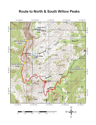
To reach the trailhead for North and South Willow Peaks, take the Tooele City exit (Exit 99) off of I-80 onto SR 36 if coming from the east, or the Grantsville exit (Exit 84) off of I-80 onto SR 138 if coming from the west. Once off the freeway on the Tooele exit, continue on SR 36 for about 3.0 miles and turn right (west) onto SR 138 towards Grantsville. Follow SR 138 (approximately 11.0 miles) through downtown Grantsville and turn left (south) onto West Street near the west edge of town. From the Grantsville exit, follow SR 138 for approximately 9.0 miles and turn right (south) onto West Street near the beginning of town just after the highway curves left (east). Head south for about 5.2 miles on West Street, which turns into Mormon Trail, and then turn right (westward) onto the road leading to South Willow Canyon. This road is paved to the forest boundary (approximately 3.3 miles) and turns to a maintained dirt road the remaining distance to the Loop Campground. Check with the Forest Service for road conditions around the Upper and Lower Narrow areas during seasons of heavy runoff.
 |
View of North Willow Peak from
the summit of South Willow Peak |
 |
View of South Willow and Deseret Peaks
from the summit of North Willow Peak |
The trail begins at the top of the Loop Campground near the restrooms and enters the Deseret Peak Wilderness Area several hundred feet beyond the information sign. At approximately 0.7 miles, the trail crosses the streambed and splits
– where you will fork to the right towards the Pockets Fork of South Willow Canyon. About 0.6 miles after the trail split, the Dry Lake Fork streambed is crossed where there is a great view of the northeast face of Deseret Peak. This view basically remains unobstructed until the crest of the ridge is reached before Pockets Fork. After approximately 1.4 miles beyond the first split, the trail splits again
– where you will fork to the left up the Pockets Fork drainage to the summit ridge. Once on the summit ridge, make your way to the right (north) up the ridgeline along what appears to be a main trail, but soon turns into a series of game trails further up. I tend to stay on the west slope of the ridge where there is less exposure. About 0.35 miles along the summit ridge is a knoll, which is bypassed to reach the true summit of South Willow Peak at 10,685 feet elevation. To reach North Willow Peak, continue northward along the ridgeline for about another 0.8 miles to the point at 10,521 feet elevation. This involves a drop of 450 feet in elevation and a regain of about 300 feet to reach this point. During the time I did it, I came across a rattlesnake just before I reached the North Willow Peak summit – perhaps the highest elevation I have ever observed a rattlesnake. Enjoy your stay, but be sure to allow plenty of time to return to the Pockets Fork Trail and back down since tedious route-finding and bushwhacking may be necessary, especially from the north summit. Distance from the trailhead to the summit of South Willow Peak is approximately 3.3 miles one-way with an elevation gain of 3,267 feet. North Willow Peak is approximately 4.1 miles one-way with an elevation gain of about 3.567 feet (taking into account a 300-foot regain after a 450-foot loss).


