Thursday, July 28, 2011

Mount Olympus

For a more commanding view of the Salt Lake Valley and surrounding areas, Mount Olympus provides a great objective.  This is quite a popular hike, and winter ascents are often made to the summit.  Rising almost 5,000 feet above the valley floor, the hike to the summit of Mount Olympus can be quite demanding, but well worth the climb once you get to the top.  Since most of this hike is on a west-facing slope, the earlier morning hours provide the coolest time of the day to hike when the route is in the shade of the mountain.  To reach the trailhead, drive along Wasatch Boulevard in the vicinity of 5800 South (approximately 1/4 mile north of Tolcate Hills Road) where you should see a brown sign indicating the Mount Olympus Trailhead.  You can park along Wasatch Boulevard or in a parking lot just north of the trailhead.  Vandalism of vehicles has been known to take place by juveniles in the parking lot, so don't leave any valuables in your vehicle or if you feel more comfortable, park along Wasatch Boulevard.
The first section of the trail passes over private land, so stay on the trail as it switchbacks through the open grassy area above Wasatch Boulevard towards Tolcats Canyon.  After about a 1/2 mile, the trail crosses into the Mount Olympus Wilderness Area, which was established in 1984.  It's difficult to consider yourself hiking in a wilderness area when you turn and see the urban sprawl behind you, but the wilderness status was needed to protect the land.  Once you cross the usually dry creek bed of Tolcats Canyon, the trail climbs steeply through several vegetative zones to the ridge above.  It is not uncommon to see rattlesnakes in this area, so be alert.  By the time you reach the ridge at approximately 8,400 feet elevation, you're in the pine trees.  From this ridge it's a scramble of less than 1/4 mile to the left (north) to the 9,026-foot south summit of Mount Olympus.  Care must be taken in this area not to dislodge rocks onto hikers below.  While some sources put the one-way distance as high as 3.7 miles, based on my calculations, it is closer to 3.2 miles one-way with an elevation gain of 4,150 feet from the trailhead.  The north summit of Mount Olympus is 67 feet lower than the south summit, and requires more technical traversing to reach it from the south summit.  
View of downtown Salt Lake City from
the south summit of Mount Olympus
The two peaks of Mount Olympus ablaze
in sunset Photo credit: Joseph Bullough


Sunday, July 24, 2011

Neffs Canyon

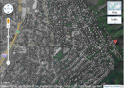
For a pleasant hike that's not real crowded with people (other than the neighborhood regulars), Neffs Canyon is a great destination to go.  Beginning at the Olympus Cove area on Salt Lake's east side, Neffs Canyon is the next canyon south of Mill Creek Canyon.  It runs along the north base of Mount Olympus, and has many springs flowing into it.  As a matter of fact, the famed "Mount Olympus Spring Water" comes from the springs in this area.  The trailhead is reached by turning east off of Wasatch Boulevard (towards the mountains) onto 4280 South, which eventually turns into Oakview Drive.  Turn left (northeast) onto Parkview Drive and then right (southeast) onto Park Terrace Drive.  Take another right (east) onto White Way and follow it to the end where there should be plenty of parking available.
Route to the Neffs Canyon trailhead
From the parking area, a well-marked trail heading to the east takes you to a graded service road, which rises along the north slope of the canyon for about a half-mile past a water tank.  At the end of the service road you reach a wide stream crossing where you can cross on rocks to the south side of the stream.  When hiking in this area as well as further up, you can't help but notice the huge rock slabs that form the north face of Mount Olympus jutting up to the right (south).  Stay on the most worn parts of the trail to reach the 8,000-foot meadow area, which is approximately 2.5 miles one-way from the parking area with an elevation gain of 2,400 feet.

A little known fact about the Neffs Canyon area is that it's home to one of the deepest caves in the United States.  At a measured depth of 1,186 feet, the cave is extremely dangerous and off limits to the novice spelunker.  The Forest Service has, in fact, closed off the cave to keep unauthorized people out.  Admission is granted only to experienced spelunkers.
The north face of Mount Olympus
taken near the mouth of Neffs Canyon
Rock outcrop at the Neffs Cave
entrance up Neffs Canyon


Saturday, July 9, 2011

Grandeur Peak

For a spectacular view of the Salt Lake Valley that's a little more involved than Ensign Peak, Grandeur Peak provides the perfect vantage point.  While this mountain can be accessed anytime of the year, I hiked it during October when the leaves were at their peak in changing color.

There are two common routes you can take to reach the summit of Grandeur Peak.  The West Ridge Route, which is the one I haven't taken, can be accessed from 3300 South and Wasatch Boulevard.  Head east to stay on Wasatch Boulevard where it will immediately turn north and parallel I-215.  Follow Wasatch Boulevard to its end where plenty of parking should be available.  The following link has more information:  http://climb-utah.com/WM/grandeur.htm.
Routes to Grandeur Peak Map credit: Joseph Bullough
The Church Fork Route is perhaps the more popular of the two.  This is accessed by driving up Mill Creek Canyon to the Church Fork picnic area, which is just past the Boy Scouts’ Tracy Wigwam area.  When I went, there was a fee of $2.25 per vehicle for accessing Mill Creek Canyon that is paid upon leaving the canyon.  I understand that the fee is $3.00 per vehicle now, and an annual pass of $40.00 can be purchased if the canyon is visited frequently.  A narrow road winds through the Church Fork picnic area to the trailhead.  Parking is limited in this area, so be prepared to park on the main road, if necessary.  From the trailhead, the trail heads north along Church Fork and crosses a trail known as the Pipeline Trail.  As Church Fork veers to the right (east), the trail goes through several switchbacks before it reaches the crest of the ridge.  From here you begin to have a commanding view of Parleys Canyon and the Salt Lake Valley.  Following the ridge, it’s about another half-mile to the 8,299-foot summit of Grandeur Peak.  Distance from the trailhead to the summit is about 2.7 miles one-way with an elevation gain of approximately 2,350 feet.
View of downtown Salt Lake City
from the summit of Grandeur Peak
View of Mount Olympus and the Cove
area from the summit of Grandeur Peak