To reach Alta from the Salt Lake Valley, take the 6200 South exit (Exit 6) off of I-215 and turn right (at the light) onto Wasatch Boulevard (SR 190). Continue south along Wasatch Boulevard past Fort Union Boulevard (7200 South), which turns into SR 210. Follow SR 210 all the way to Alta (approximately 12.0 miles from Fort Union Boulevard). From I-15, take the 9000 South exit (Exit 295) and turn eastward towards Sandy along 9000 South (SR 209), which eventually turns southward and then eastward again as 9400 South. SR 209 weaves a little more before it terminates at approximately 7.3 miles from the I-15 exit. At the junction, turn right (eastward) and follow SR 210 the rest of the way to Alta (approximately 8.0 miles from the junction). Near the mouth of Little Cottonwood Canyon lies a huge vault carved into the granite that stores extensive genealogical records. Some of the granite in this area was quarried in earlier days for construction of the Salt Lake LDS Temple, and more recently the Conference Center. While the grandeur of this canyon may be eye-catching, be sure to keep your eyes on the road while driving, and watch out for bicyclists. Upon reaching Alta, look for the Shallow Shaft Restaurant along the left (north) side of the highway, where there should be parking space available.
 |
| View looking southeast towards Alta and the Albion Basin from Cardiff Pass |
 |
| View looking west to Mount Superior from a knoll just west of Cardiff Pass |
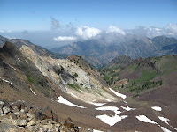
The route to Mount Superior begins at the road left (west) of the Shallow Shaft Restaurant. Follow the road as it curves through the structures, keeping to the right for about 0.2 miles. Veer to the left (northward) onto an unimproved road that climbs westward to a hill towards Cardiff Pass. At approximately 0.8 miles from the starting point, take the trail extending left (west) of the road and follow it for about 0.6 miles to reach Cardiff Pass. An effective guide to keep you on course is to generally follow the power lines that lead up to the pass. Situated at just over 10,000 feet elevation, Cardiff Pass offers a great view of Alta and the Albion Basin below, and provides a great stopping point for those who don't want to hike the whole way. Continuing on to Mount Superior, follow the apparent trail along the ridge to the left (west) of Cardiff Pass, which will skirt to the south of a point listed as "10277" on the map. Upon rounding the ridge, Mount Superior comes into view straight ahead, which isn't as daunting as it appears. Keep following the indistinct trail that traverses along the Little Cottonwood side of Cottonwood Ridge. While exposure along this part of the route is not particularly high, care should be taken not to slip on loose rock and fall to the steeper slopes below. The final half-mile of the hike involves scrambling up a rock slope with an elevation gain of about 1,000 feet. A false summit is passed along the way before reaching the true summit of Mount Superior at approximately 11,050 feet elevation. Distance from the starting point to the summit is approximately 2.5 miles one-way with an elevation gain of approximately 2,500 feet (taking into account a 1,000-foot gain after a 100-foot loss). When I reached Mount Superior's summit I had planned to hike the short distance to reach Monte Cristo's summit, but billowing clouds looked threatening and I chose not to chance it. Monte Cristo is situated another quarter-mile further west along Cottonwood Ridge. Reaching its 11,132-foot summit involves a 160-foot elevation gain after an 80-foot loss from Mount Superior.
 |
| View looking west to Monte Cristo from the summit of Mount Superior |
 |
| View looking towards Lake Blanche and Big Cottonwood Canyon from Mount Superior |
